


 Subscribe


- A Cottonwood Seed
- BehindTheBins
- Bird Cinema
- Bird Freak
- BirdChaser
- Birdfreak
- Birding for Handicapped
- Birding is Fun
- BirdingOnTheNet
- BirdNote Podcasts
- Birds, Etcetera
- Central NM Audubon
- Chapel Trail Nature Ctr
- Children & Nature
- Cornell Online BirdGuide
- Cottonmouth moccasin
- Eagle Nest
- Great FL Birding Trail
- Hawks Bluff Park
- Illinois Birders' Forum
- Janine Images
- Jones Meadow Park
- Kane County Audubon
- KidWings
- Laura's BirderBlog
- Les Arends FP
- Lippold Park
- Nature Photography
- Nelson Lake FP
- New Jersey Audubon
- Ornithology Course
- Rick Wright
- S Florida Eagle Watch
- Somewhere in NJ
- South Florida Audubon
- SurfBirds
- The Hawk Owl's Nest
- Tropical Audubon
- Tucson Audubon
- Vermillion River Wildlife
- West Miramar ESL
- Wild Bird Wednesday
- WingAndSong NM Blog
- BirdChat
- BirdNote Podcasts
- Bird News Network
- I and the Bird
- Ask a Bird Guide: If birds disappeared tomorrow, what would you do instead?
- Interview with Anders Hundebol, Developer of the Birdey bird ID game
- Bird Guides of the World: Edward Bonavia, Malta
- Birding Lodges of the World: Maquenque Lodge, Costa Rica
- A few more birds of Luzon, The Philippines
- Three Photos: Iconic Birds of Boca Tapada, Costa Rica
- Tracking the Elusive Ghost of the Forest: The Sri Lankan Bay Owl
- San Juan De La Costa
- Ask a Bird Guide: If birds disappeared tomorrow, what would you do instead?
- FL Migration Radar
- General
- Birding & Outdoors
- Rutherford & NJ
- NM & SW US
- Florida & SE US
- Medical
- INDEX to Blog
- Hurricane Camille
- Getting Drafted
- Supai Canyon AZ
- Grandchildren
- Sandia Crest
- Capulin Spring
- Illinois
- Birding “Patches”
- Bald Eagle Nest
- Alaska
- MyWorld
- Wild Bird Wednesday
- Book Reviews
- Bird D’pot
- November 2012
- October 2012
- September 2012
- August 2012
- July 2012
- June 2012
- May 2012
- April 2012
- March 2012
- February 2012
- January 2012
- December 2011
- November 2011
- October 2011
- September 2011
- August 2011
- July 2011
- June 2011
- May 2011
- April 2011
- March 2011
- February 2011
- January 2011
- December 2010
- November 2010
- October 2010
- September 2010
- August 2010
- July 2010
- June 2010
- May 2010
- April 2010
- March 2010
- February 2010
- January 2010
- December 2009
- November 2009
- October 2009
- September 2009
- August 2009
- July 2009
- June 2009
- May 2009
- April 2009
- March 2009
- February 2009
- January 2009
- December 2008
- November 2008
- October 2008
- September 2008
- August 2008
- July 2008
- June 2008
- May 2008
- April 2008
- March 2008
- February 2008
- January 2008
- December 2007
- November 2007
- October 2007
- August 2007
- July 2007
- June 2007
- May 2007
- April 2007
- March 2007
- February 2007
- January 2007
- December 2006
- November 2006
- October 2006
- September 2006
| M | T | W | T | F | S | S |
|---|---|---|---|---|---|---|
| « Nov | ||||||
| 1 | 2 | 3 | 4 | 5 | ||
| 6 | 7 | 8 | 9 | 10 | 11 | 12 |
| 13 | 14 | 15 | 16 | 17 | 18 | 19 |
| 20 | 21 | 22 | 23 | 24 | 25 | 26 |
| 27 | 28 | 29 | 30 | 31 | ||
Posted by: Ken @ 3:14 pm

Yesterday morning I had a goal in mind as I set out into the mile square area of wetlands, my local birding patch. I would visit the overnight roosting place of the Short-tailed Hawk that I had photographed earlier this week:
Twice before on my morning walks, as passing by a certain maple tree, I was surprised to see a dark-backed hawk emerge from deep within its leaves. The first time, it flew off so quickly that it was impossible for me to see any details of its plumage or shape, except that it was fairly large and looked almost black. Though it appeared to be a raptor with long rounded wings, and left me a bit puzzled as to its identity, I did not think about it much after that.
Then, last week, I was startled when I flushed a similar raptor out of the same tree. As before, it was a dark bird, quite large, and it was dark above and uniformly light underneath. This time I got a better view, and saw that its head was black, in a pattern almost like the “helmet” of some Peregrine Falcons. However, there was no barring on its breast and its wings were not pointed like a falcon’s. About a half hour later I saw my first light morph Short-tailed Hawk making lazy circles above the wetlands.
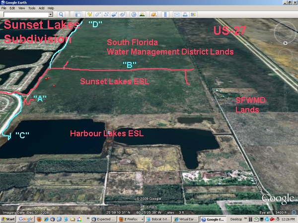
My walk followed the red line on this map, which provides an aerial view looking to the south over the wetland I call the “West Miramar ESL. ” The unpaved E-W road/track in the foreground is Pembroke Road, which will eventually connect with US-27 — how it will traverse the NW portion of the completed C-9 is a mystery to me. [ESL= Environmentally Sensitve Land or Area (ESA) set aside under agreements with developers to “mitigate” the effects of their activities on wetlands. I do not know all the details of the agreements, but rights are conveyed to the South Florida Water Management District (SFWMD) which incorporates them into Water Preservation Areas (WPAs) that are part of the overall Comprehensive Everglades Restoration Plan (CERP) administered by the US Army Corps of Engineers]:
Only after I got home did I connect the two sightings. It is a bit unusual to find a large raptor hiding in the foliage. Accipiters (”bird hawks”) such as the Sharp-shinned Hawks, and sometimes Cooper’s Hawks will hunt that way, hiding in seclusion and darting out to capture a smaller bird. Most Buteos (the group name for many larger hawks such as the Red-tail) seem to prefer perching on an exposed branch that provides a good view of the surrounding area, the better to find rabbits and rodents. However, the Short-tailed Hawk is rarely seen roosting out in the open. It characteristically deep within the branches of a tree, waiting for the ground to warm up and produce thermal currents to loft it effortlessly and allow it to float up very high as it looks for its prey, which consists almost exclusively of other birds. The roost of the Short-tailed Hawk is notoriously hard to find.
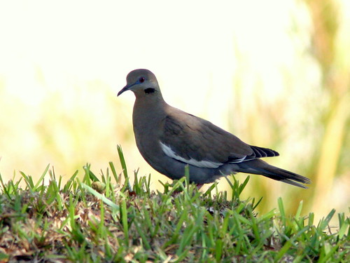
I hoped to verify that the hawk had selected that particular Red Maple tree, the largest and fullest of the few hardwoods that grow along the path leading into the heart of the wetland. It was early, and I birded my way along the mile of footpaths that led to that tree. My first stop was a thicket of mostly exotic shrubs, mercifully spared by the landscaping contractors who occasionally groomed the subdivision lands that abutted the wetlands (marked “A” on the above map). To my surprise, I found a half dozen White-winged Doves that appeared to have spent the night there.
One dove settled nicely atop the berm that runs along the dirt road:
Near the dove, a (Western) Palm Warbler posed for an eye-level portrait as it ate a small insect: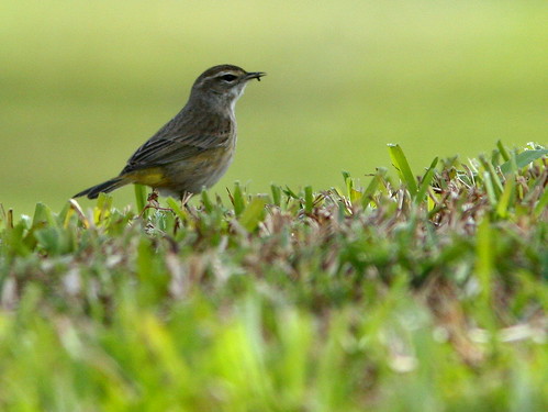
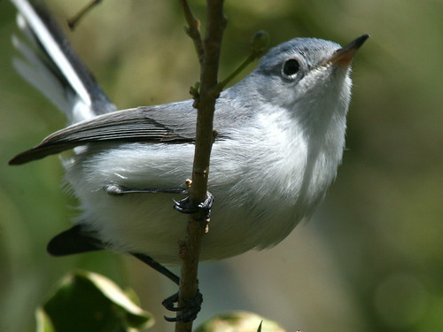
A Blue-gray Gnatcatcher approached me so closely that I had to switch my lens to a macro setting, and still could not fit the entire little bird in my viewfinder:
A male Common Yellowthroat peeked out at me from behind his mask:

Continuing along the trail that borders the west side of the 196th Avenue Canal, I reached the intersection of the path that leads westward, into the heart of the wetlands.During summer it is flooded, but the water receded about a month ago and it was now mostly dry. With my binoculars, I checked out the trail, as it sometimes is occupied by deer and once, a Bobcat. This time, I could make out the figures of one or two Black Vultures on the ground, about a half mile away. Then I thought I saw a four-legged creature just behind the vultures. Keeping to the side of the trail to break up my silhouette, I moved closer very carefully.
A ditch runs along the north side of the trail, and it was teeming with fish. During the wet summer, the fish were free to swim everywhere in the wetland, but now they were concentrated in the ditch. This was an ideal situation for long-legged waders, especially tactile feeders such as Wood Storks and ibises.
As I moved along parallel to the ditch, the startled birds, such as this Wood Stork, flew up and moved ahead of me: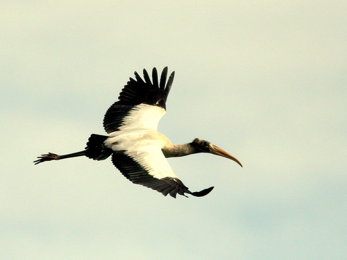
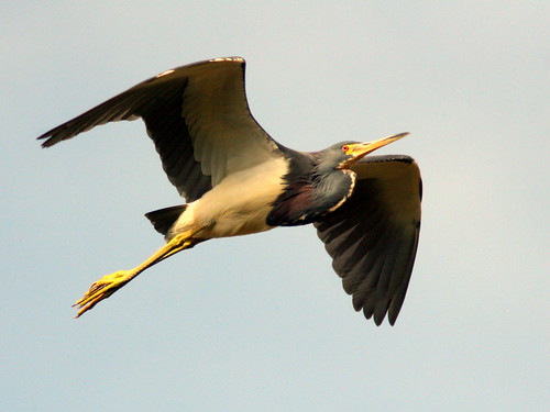
A Tricolored Heron circled back behind me:
A group of immature storks clustered on a treetop:

In the distance, I picked out the subtle differences between an immature Little Blue Heron, on the left, and a Great Egret: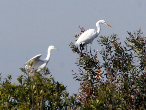
Despite all the distractions, I kept working my way, trying to stay up on the edge of the trail out of sight of whatever creature might be ahead. When I was about 1/4 mile from the vultures (which were about at the point marked with a “B” on the topo map), I took several photos. None turned out very well.
Although heavily cropped, my images revealed not one, but two Bobcats:
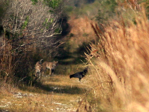
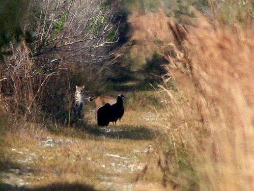
The cats were apparently eating a prey item, and the vultures were standing by, hoping for some scraps. I kept moving nearer, as quietly as possible, but when I looked again they had disappeared. Then, I walked down past the area where they had gathered, and was surprised when both suddenly ran across the trail only about 50 feet ahead of me. There was no time to grab the camera.
I walked back, hoping to find some nice tracks in puddles, but among the many raccoon tracks, found only one that appeared to have been an overlay imprint of the back foot over the front (as an expert tracker pointed out to me, this is technically an “overstep or indirect register as it’s termed where the hind foot does not always go exactly into the front print:” 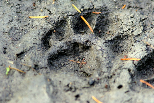
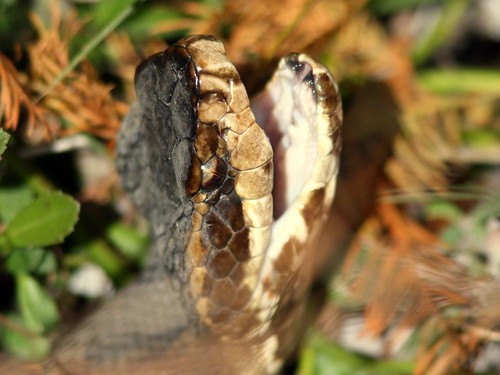
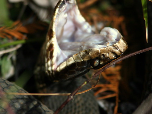
While looking for the tracks, I kept to the north side of the trail, hoping that the sun, now to my right, would cast shadows to make them show up better. Of course, I kept an eye out for snakes, but my peripheral vision picked up flash of white, only about three feet to my left:
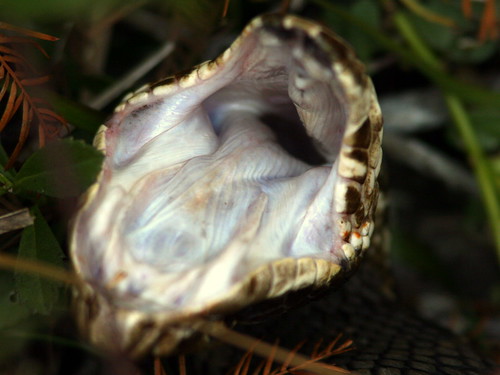
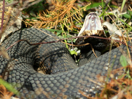
The snake was about four feet off the trail. I only had my long lens, and (in my heightened state of awareness) I did not want to back up into the high grass on the other side of the path to try and fit its whole body into the picture. When I blocked the sun it reacted again. I realized that my shadow had passed over the snake as it was resting in the sun, and this caused it to go into its classic threat display. Now I know first hand why they are called “Cottonmouths!”

January 14th, 2010 at 8:26 pm Very nice, I haven’t been down there sine I lived in Hialeah in the 70’s. I used to spend many many days and nights out in the wetllands off US-27/Krome ave. not to mention all along US-41. It was off Krome just a bit norht of the Tamiami trail i got nailed by a Pygmy Rattlesnake. Trust me you do not want to do that. I was capturing them for sale at the time, so it was entirely my fault. It was out by 40 mile bend on US-41 that one of these guys bit me. Fortunately I did not suffer any major necrosis but the pain is almost indescribable. I now collect them with my camera. Peace Dave
January 14th, 2010 at 9:24 pm Thanks, Dave. I usually give these guys a wide berth. This is the second time that I got as close to a Cottonmouth without seeing it first. The other time, one slithered out of the grass next to the trail about 3 feet away. I don’t think it noticed me– it was all wet, having just come out of the water.Generally, I keep to the open trails and am especially careful when I have to step into grass. After my first scare, everything that was slightly crooked and dark looked like a snake! Ken
January 15th, 2010 at 7:06 am There seems to be no means of entry to the “West Miramar ESL” other than via the unpaved west end of Miramar Parkway. The problem is that the dead end of the road is posted and Miramar prohibits on-street parking. Police patrol inside the area at times, but have (so far) been friendly to pedestrians. Some people park along the fence, being careful not to block the gate, but I’m not sure it is legal. I simply walk in legally on Sunset Lakes HOA property, as I am a resident.
I’ve never tried to access the area by way of the eastern end of Pembroke Road, off US-27, but this may only lead to the west side of the Harbour Lakes ESL– there seems to be no trail to the east from there. I’ve only seen fishermen use that area. Access from the north on 198th Avenue is blocked by water, a fence and private property.
A couple of planned changes will impact the area, depending upon availability of public funds. The first will be completion of the extension of Miramar Parkway, which will curve north and become 196th Ave, joining up with Pembroke Road and US-27 (but probably not directly north to join Pines Boulevard). This will change access to the ESLs, for better or for worse. It will also turn Miramar Parkway into another main artery to connect the area west of I-75 with US-27.
The other is a CERP (Comprehensive Everglades Restoration Program) project to create two new Broward County Water Conservaion Area impoundments (C-11 and C-9) along US-27. C-11, in western Weston is scheduled to be completed first. C-9 will include the SFWMD lands south of the eagle nest, west of Miramar and possibly much or all of the Sunset Lakes and Harbour Lakes ESL’s. Dikes would be increased in height to about 12 feet, and the entire area could become a huge lake with up to 4 or 6 feet of water, functioning as a STA to block seepage to the east and help in flood control, as well as settle out phosphates to purify the water for release into the Everglades sheet flow. Of course, the entire character of the area would thereby be changed drastically.
I’m not sure of the exact boundaries of C-9. A SFWMD representative will provide the Pembroke Pines Bald Eagle Sanctuary Steering Committee with a briefing at our next meeting at the end of this month. Minutes of the meetings are available at links on the Eagle Nest Watch main page.
January 15th, 2010 at 9:36 am What an awesome story and supporting photos. The photo quality is outstanding. Would like to photograph this site myself. One day, I suppose. Thank you for writing this up!
January 15th, 2010 at 8:22 pm For the record, here is my eBird list of bird sightings: Location: West Miramar ESL Observation date: 1/13/10 Notes: Photographed two Bobcats eating prey with two Black Vultures standing by. Also photos of Cottonmouth Moccasin next to trail. Number of species: 33 Muscovy Duck (Domestic type) 6 Mottled Duck 2 Anhinga 4 Great Blue Heron 4 Great Egret 15 Snowy Egret 3 Little Blue Heron 2 Tricolored Heron 1 Black-crowned Night-Heron 2 White Ibis 8 Wood Stork 10 Black Vulture 25 Turkey Vulture 10 Northern Harrier 1 Red-shouldered Hawk 1 Ring-billed Gull 8 Rock Pigeon 20 White-winged Dove 6 Mourning Dove 4 Eastern Phoebe 1 Loggerhead Shrike 3 Blue Jay 4 Tree Swallow 100 Carolina Wren 1 Blue-gray Gnatcatcher 5 Gray Catbird 2 Northern Mockingbird 12 Yellow-rumped Warbler (Myrtle) 3 Palm Warbler (Western) 10 Ovenbird 1 Common Yellowthroat 6 Swamp Sparrow 1 Common Grackle 6 Boat-tailed Grackle 12 This report was generated automatically by eBird v2(http://ebird.org)
January 16th, 2010 at 7:35 am FYI– If any reader can correct or elaborate upon my response, please do so. I’m just learning about CERP myself! Ken
Hi Ken, I wanted to comment on your response about access to sunset lakes ESL. I too am a sunset lake resident. I bought a beautiful home overlooking the everglades preserve on 195th terrace when I moved down from DC last year.. Now I was told by the county that there would be no further development near or around me. I’m not sure I wouldn’t mind seeing a road push thru the dead end of miramar parkway to connect to 27 (since my office is in Doral and I fly out of MIA constantly); I’m more concerned about this CERP you mention. I was told that I didn’t even need flood insurance.
Your description, should this go through, sounds like I may have water in my house whether I like it or not. Might you have a web link to updated information on this project. I guess I shouldn’t put off getting flood insurance even though my property was deemed high enough. thanks, L–
= = = = = =
Hi, L– As I understand it, the main purpose of CERP is to restore sheet flow of clean fresh water to the historic Everglades, at least to the 1/3 to 1/2 of what is left of the “River of Grass.” To do this, many of the ditches and canals that were dug in the middle of the last century to “reclaim” the land for agriculture and development must now be undone. Aside from the adverse aesthetic and ecological effects, this drainage system also wasted rainwater into the ocean rather than allowing it to recharge our aquifer, which is the source of our drinking water.
To control the water flow, CERP is constructing a system of water preservation reservoirs or impoundments. These trap rain water and release it more predictably, actually reducing the threat of flooding in developed land to the east, such as Sunset Lakes. The planned local C-11 and C-9 impoundments will require levees that are higher than those that you can see along the west side of the 196th Avenue canal (An example of the higher levees are those along the west side of US-27). They will actually serve as part of the system of Stormwater Treatment Areas (STAs) that remove excess phosphorus from the water before releasing it to the sheet flow.
The phosphorus comes mostly from fertilizer used in agriculture, especially sugar cane cultivation, as well as mining. Healthy Everglades water is normally very poor in nutrients, and the phosphorus helps cattails and exotic plants to replace the Sawgrass. The native plants evolved in the nutrient-poor ecosystem, and are unable to compete with the well-fed invaders.
So, the bottom line is that our flood threat would actually be diminished by CERP activities. However, we also did not need flood insurance, but bought it anyway. We almost needed it during Hurricane Wilma, when palm fronds accumulated in the streets at the height of the storm, and blocked the storm drainage right in front of our house. The water rose almost to our front door before a neighbor ran out with a rake and unblocked the grating. Having both flood and general homeowners insurance avoids the finger-pointing when there is a question about which policy covers water damage of any kind. Since we are above the flood zone, it is not all that expensive for the peace of mind that flood insurance provides. Besides, though our lake did not rise that much with Wilma, a 100 year flood could hit any time.
I hope that the SFWMD presentation will provide us with a more specific timeline and also a more exact understanding of the topography of the C-11 and C-9 projects. If you Google “CERP” and “SFWMD” you will obtain lots of information, but so far I have not found a clear map of the boundaries of the planned local impoundments. Start here: http://www.evergladesplan.org/index.aspx Since these activities will impact the foraging areas of the local eagles, the Steering Committee has a vital interest in them, and we will keep everyone informed as information is obtained, hopefully in plain English– I have toruble cutting through the plethora of acronyms. I still don’t know what the “C” stands for in the numbering system for the water conservation projects!
Ken
February 21st, 2010 at 8:05 pm Ken, When Tim, my husband, goes deer hunting on our back 42 acres, he has seen bobcats around here. We live about 5 miles North from Thomasville. Pat