


 Subscribe


- A Cottonwood Seed
- BehindTheBins
- Bird Cinema
- Bird Freak
- BirdChaser
- Birdfreak
- Birding for Handicapped
- Birding is Fun
- BirdingOnTheNet
- BirdNote Podcasts
- Birds, Etcetera
- Central NM Audubon
- Chapel Trail Nature Ctr
- Children & Nature
- Cornell Online BirdGuide
- Cottonmouth moccasin
- Eagle Nest
- Great FL Birding Trail
- Hawks Bluff Park
- Illinois Birders' Forum
- Janine Images
- Jones Meadow Park
- Kane County Audubon
- KidWings
- Laura's BirderBlog
- Les Arends FP
- Lippold Park
- Nature Photography
- Nelson Lake FP
- New Jersey Audubon
- Ornithology Course
- Rick Wright
- S Florida Eagle Watch
- Somewhere in NJ
- South Florida Audubon
- SurfBirds
- The Hawk Owl's Nest
- Tropical Audubon
- Tucson Audubon
- Vermillion River Wildlife
- West Miramar ESL
- Wild Bird Wednesday
- WingAndSong NM Blog
- BirdChat
- BirdNote Podcasts
- Bird News Network
- I and the Bird
- What We Missed by Looking
- Species Spotlight: Piping Plover
- 15 countries with many bird guides
- Demotivational Posters for Birds (XXXIX)
- White-Throated Sparrow: A Poem
- The Northern Gannets of Bonaventure Island
- Ask a Bird Guide: In your area, what is the general attitude toward birds among local people?
- The Toucans That Kept Turning Up
- What We Missed by Looking
- FL Migration Radar
- General
- Birding & Outdoors
- Rutherford & NJ
- NM & SW US
- Florida & SE US
- Medical
- INDEX to Blog
- Hurricane Camille
- Getting Drafted
- Supai Canyon AZ
- Grandchildren
- Sandia Crest
- Capulin Spring
- Illinois
- Birding “Patches”
- Bald Eagle Nest
- Alaska
- MyWorld
- Wild Bird Wednesday
- Book Reviews
- Bird D’pot
- November 2012
- October 2012
- September 2012
- August 2012
- July 2012
- June 2012
- May 2012
- April 2012
- March 2012
- February 2012
- January 2012
- December 2011
- November 2011
- October 2011
- September 2011
- August 2011
- July 2011
- June 2011
- May 2011
- April 2011
- March 2011
- February 2011
- January 2011
- December 2010
- November 2010
- October 2010
- September 2010
- August 2010
- July 2010
- June 2010
- May 2010
- April 2010
- March 2010
- February 2010
- January 2010
- December 2009
- November 2009
- October 2009
- September 2009
- August 2009
- July 2009
- June 2009
- May 2009
- April 2009
- March 2009
- February 2009
- January 2009
- December 2008
- November 2008
- October 2008
- September 2008
- August 2008
- July 2008
- June 2008
- May 2008
- April 2008
- March 2008
- February 2008
- January 2008
- December 2007
- November 2007
- October 2007
- August 2007
- July 2007
- June 2007
- May 2007
- April 2007
- March 2007
- February 2007
- January 2007
- December 2006
- November 2006
- October 2006
- September 2006
| M | T | W | T | F | S | S |
|---|---|---|---|---|---|---|
| « Nov | ||||||
| 1 | 2 | 3 | 4 | 5 | ||
| 6 | 7 | 8 | 9 | 10 | 11 | 12 |
| 13 | 14 | 15 | 16 | 17 | 18 | 19 |
| 20 | 21 | 22 | 23 | 24 | 25 | 26 |
| 27 | 28 | 29 | 30 | 31 | ||
David LaPuma (Badbirdz) will be returning from his Dry Tortugas trip on Monday morning, and should be back on line with his migration radar images and interpretations. From my perch here in Illinois, I thought I would check out the migration from Cuba, as west to west-southwest winds and clear skies back home in Florida suggested that there might be some action. Lacking David’s technical abilities, the best I could do was to pluck a few radar loops from sunset until bedtime. The one hour Central Time differential allowed me to peer into the early morning hours without disturbing my sleep cycle.
These five consecutive loops of about an hour each, were captured at hourly intervals, beginning at about at about 9:00 PM EDT. The midnight loop is repeated with enhanced imagery to show relative headings of the flocks. Click on each image for a larger view.
The first loop begins around sunset, which occurred at 8:02 PM EDT in Key West. A wave of birds is moving northward from the Keys, and there are some flocks already heading out of Cuba: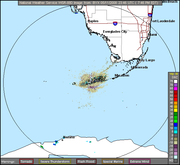
This is the next loop, from around 9:00 to 10:00 PM. The wave from the Keys is moving due north, approaching the southern tip of the mainland, and more birds are moving out into the Florida Straits from Cuba: 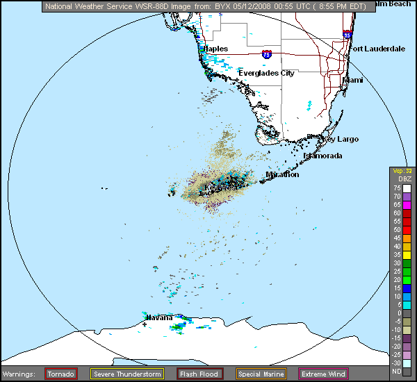
This is the third hour, from 10:00 to 11:00 PM, showing the biomass exiting Cuba’s northern coast to be quite dense:
The 11:00 to 12 midnight loop. The display fades momentarily when the signal shifts from clear air to storm setting. Note that a few storms have developed off the coast of Cuba: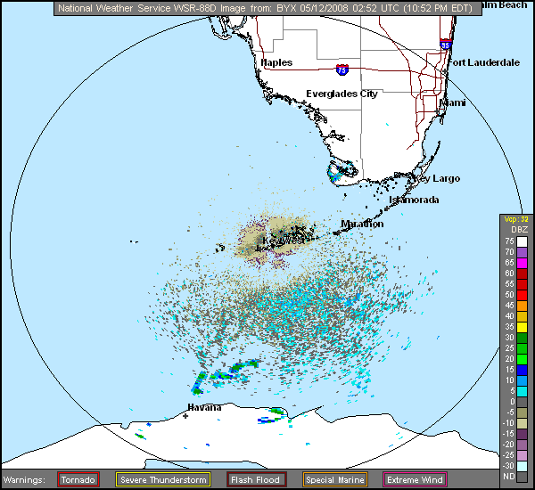
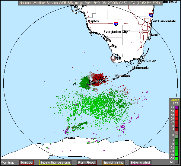
The following image shows the direction and velocity of movement of both the birds and the storms, relative to the radar station in Key West, during the hour before midnight. As I am not competent to interpret this image, I will seek a better explanation from any expert. As I understand it, the green means that the targets are moving somewhat toward the radar source, while the red means that they are moving away. It is evident that the storms are following a more easterly course than the birds, which seem headed for landfall on the Florida Peninsula and along the west coast, rather than moving northwest out into the open Gulf as noted in the images I posted during the past week.
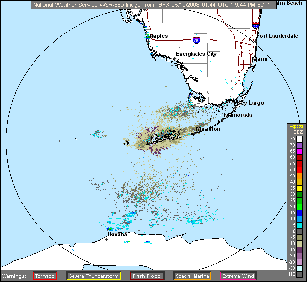
This final loop, from midnight to 1:00 AM Monday morning (Florida time), gives a pretty good impression of the northeasterly heading of the flocks, especially in the enlarged view (click on image):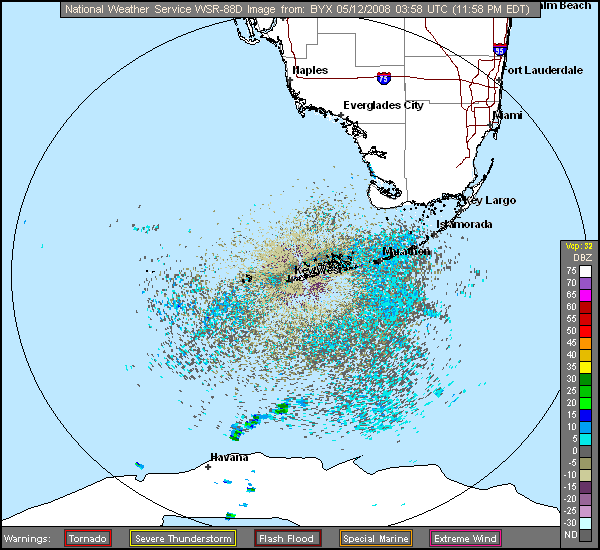
May 14th, 2008 at 4:41 pm [Isn’t it great to have a meteorologist for a son? Thanks, Ken!!]
Dad, The second to last image is showing the base velocity from the Key West Doppler radar. You are correct in that the green returns are movement toward the radar site while the red returns are movement away from the radar. There is definitely a very large mass of echoes, most likely migratory birds, which are moving in a northeasterly direction southwest to southeast of the radar site. These returns are moving roughly 30 knots or so.
Also, the returns (birds) become red as they pass east of the radar near Marathon indicating that they are heading toward the mainland. Interestingly enough, some darker greens are located just west of the radar with darker reds just east of the radar which do not appear to be moving. This would be the wind direction and speed in Key West. The velocity legend indicates that these returns are moving from west to east about 5 to 10 knots and the observation from Key West International Airport at that time was west wind at 5 to 10 mph.