 Update on the Rosy-Finches of Sandia Crest, New Mexico. The flag has stopped waving. Although individuals or a few finches have been seen since April 4th, there have been no appreciable flocks. One Black Rosy-Finch was coming in for seed on April 8. Feeders and sighting logs were removed April 9th. Report any late sightings directly by e-mail to Ken.
Spring Snowfall on the Sandias
It takes about 55 to 60 minutes to drive the 40 miles from the Albuquerque airport to Sandia Crest. Half is on I-40 at 65-70 mph; about 6 miles on NM 14 at 35 mph or so, and the last 13 miles is on the Crest Road, which takes about 25 minutes under good weather conditions.Visitors to Albuquerque planning to see the rosy-finches sometimes confuse Sandia Peak with Sandia Crest. The peak is the summit of the ski run, and is at about the same elevation as Sandia Crest, but it is a couple of miles to the south. There is no road to Sandia Peak, and there are no rosy-finch feeders there, either.
From Albuquerque, an exciting tram ride up the west face of the Sandias, or an arduous climb up La Luz Trail are the only direct paths to Sandia Peak. The other alternative is to drive out to the east on I-40, north on NM-14, and then about 8 miles westward up the road to Sandia Crest and take the ski lift from the base. Birders have planned entire trips just to see the rosy-finches, thinking they would be at the top of the tram ride, at Sandia Peak, only to be surprised and disappointed. Others see the relative proximity of the two summits and think they might just walk the trail between them.
In winter, this can be a dangerous mistake, even if one is acclimated to the high altitude and prepared with warm boots and cold weather gear. Wind chills can be extreme. The trail itself may disappear into deep drifts and course dangerously near the sharp drop-off of the western face. When there are warm spells, the snow may partially melt and then turn into ice. Even in the summer, a cumulus cloud may form rapidly over the rising air, and blue skies suddenly produce severe wind, rain and large hail. So, never try that route to Sandia Crest!
This morning, USFS Volunteer David Hammack provided this report to the Cibola Trail Rangers Yahoo Group:
Subject: Winter returns to La Luz trail!
Crest Spur trail to Sandia Crest (10,678 ft.) or La Luz trail to Tram : The storm of April 9 deposited 8 to 12 inches of fresh powder snow on these upper trails. Conditions will change rapidly in the next few days, with the snow changing to ice and then melting.
Migration Over the Straits of Florida
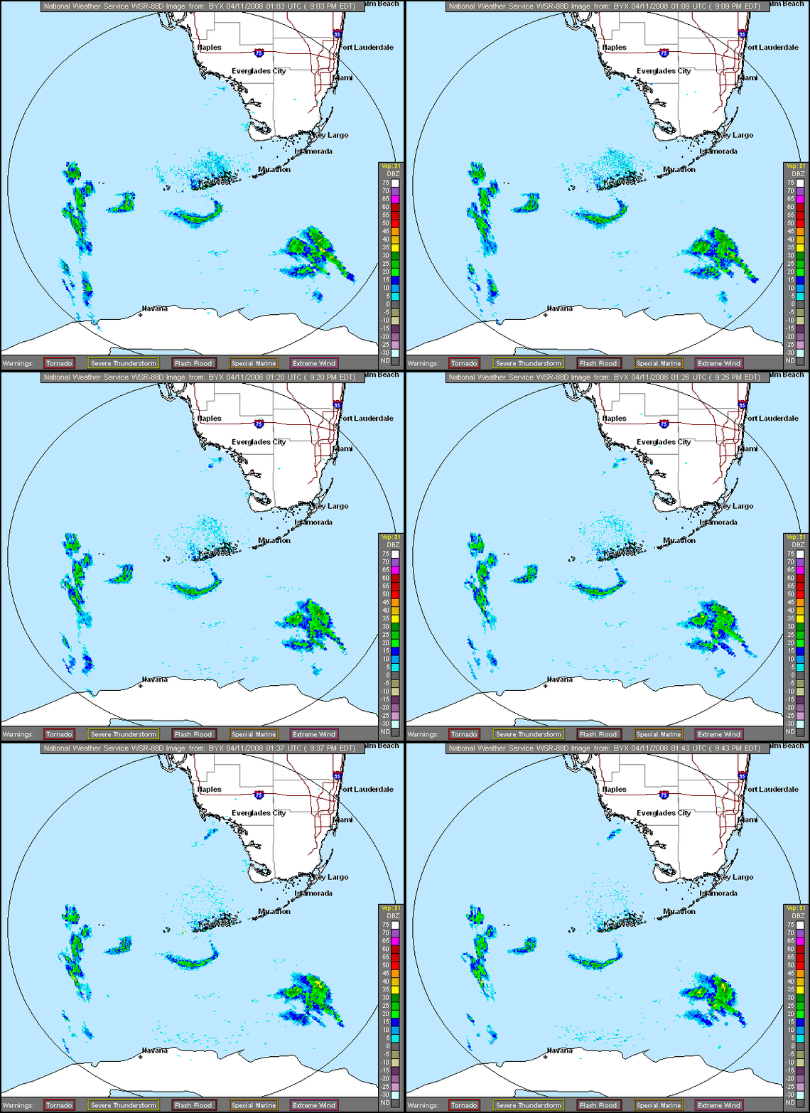
This evening, I checked the Key West Radar at about 9:45 PM, and the early results look promising on this one-hour loop. Migrants are just beginning to stream northward from the north coast of Cuba and the lower Florida Keys, at right angles to the easterly winds and storms. In the morning, be sure to check BADBIRDZ to see radar loops of migration events during the night.
|
BirdBlogBytes |
|
| Save Our Boreal Birds | The Boreal Forest is a vitally important breeding ground that supports more than half of the North American populations of over 100 bird species, and it is steadily being carved up by unchecked development. |
| BirdChaser | Birdchaser interviews Howard Cosell on the Sport of Birding, and yours truly chimed in. |
| Hawk Owls Nest | Butterfly Conservation Web site announced |
| Broward County Audubon | Florida Legslature eliminates Everglades protection and cleanup funds |
| Badbirdz Reloaded | Migrants again departing Keys and crossing from Cuba |
| Somewhere in New Jersey | Laura has eaglets as new neighbors |


